

August 2nd to the 4th current gale of precipitation


- Details
- Category: Ningbo News
- Published: Tuesday, 31 July 2012 09:47
Source 2012-7-31 8:54:00 Southeast Business
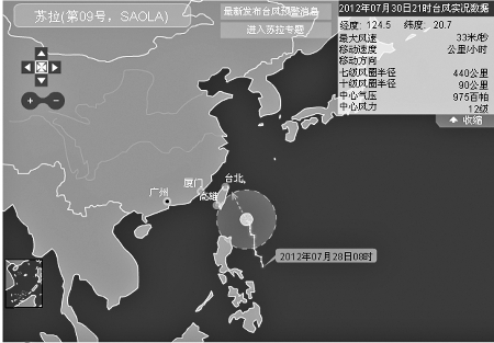
Central Meteorological Station forecast road map
Municipal Meteorological Observatory released yesterday, this year the first tropical cyclone. After 24 hours of brewing, this year's No. 9 strong tropical storm "Sura 14:00 yesterday to strengthen into a typhoon. August draws near, the typhoon season has opened the curtain.
Reporter Dan Chengcheng
August 2nd to the 4th gale precipitation
According to information released by the Municipal Meteorological Observatory yesterday 17:00, 14:00, "Sura" The center is located in the city 1140 kilometers east over the ocean, the wind near the center of 12 (33 m / sec). "Sura" will be 5 to 10 km per hour speed is expected to move to the north-northwest direction, and gradually close to the eastern ocean to Taiwan, the intensity will also continue to strengthen. Is expected that tomorrow the city the waters south of the wind will gradually increase to 7 to 9.
City Meteorological Station chief forecaster Pang Baoxing said, can not be sure "Sura" will give the city what kind of impact, the observatory will closely monitor their movements. However, from the current forecast, influenced by the typhoon circulation tonight Ningbo, coastal sea wind will gradually increase, especially in the August 2 to 4 days maximum wind speed of up to 9 to 10. In other words, the sea will appear on the scene of the waves rolling roar. August 2 to 4 may also be the process of heavy rainfall, then also there may be a big rainstorm.
The main urban areas today and tomorrow, cloudy to overcast weather with showers in some areas. Wind of urban areas will be the southeast wind turned east to northeasterly winds, maximum wind of up to four, visually, that is, walking down the road you can see the "dusty".
Landing path is not yet clear
Apart from the "Sura", in the western Pacific, there is a tropical storm, "David" is also eyeing.
Between pairs typhoon involves the impact will produce the "Fujiwara effect" in meteorology. The so-called "Fujiwara effect" refers to two shares of tropical cyclones around the common center of rotation, the two interactions will produce what the consequences are difficult to predict, may be a tropical cyclone to dominate the direction of movement of the other shares, and even volume large number of "eat" the small size of some of; may also be two tropical cyclones each other arranged; may also be a follower of a movement; or double-typhoon effect does not occur between them.
The national meteorological agency forecast the typhoon moving path there is a big difference. Some say that the "Sura" will be landing in Jiangsu, while others will be landing in Wenling, Zhejiang Province, there is a forecast, "Sura" grazed Taiwan landed, Zhejiang, Fujian and the junction. Taking into account the "David" from our country still a long way, "Sura" and "David", how they interact is not yet clear, China's east and south China coastal areas should be well in advance of preventive measures.
This year the city suffered two to four typhoons
Has now been nearly eight months, many people feel that this year's typhoon late.
In fact, the figure of the typhoon as early as spinning around us. As in early June of this year, by March this year, Typhoon Mawar impact the city on the precipitation process. Impact is more pronounced in the mid and late June, the rainy season with a super typhoon on the 4th of this year the ancient super, the combined effect of the outer circulation of tropical storm on the 5th of this year, "Terry", the city has a strong process of precipitation The city meteorological establishment of the station, the rainfall record (1954) since the rainy season during a single rainstorm record, approaching the city year-round rainy season (260 mm) half.
Pang Baoxing said that compared to July, August is the typhoon city is the most serious of the month. If you must give affected by the typhoon month row name, severity, followed by August, September, July.
Although there are certain rules to follow, but the typhoon really is a headstrong guy. Statistics show that the impact of the city typhoon first appeared in May, for example, No. 1, 2006, typhoon "Pearl" and began to affect the time is May 18; latest may appear in the December, 2004, for example on the 28th Typhoon Nanmadol, began to affect the time is December 4.
It is understood that, this year there may be two to four typhoons in the city, close to affect the number of the years of 3.1.


